Asia Geomatic Instruments Sdn Bhd (728101-X)
28B, Jalan Jernai 2, Medan Idaman Business Centre, Batu 5, Gombak, 53100 Kuala Lumpur, Malaysia
Asia Geomatic Instruments Sdn Bhd (728101-X)
28B, Jalan Jernai 2, Medan Idaman Business Centre, Batu 5, Gombak, 53100 Kuala Lumpur, Malaysia
Tel : +6 03 4021 0081
Fax : +6 03 4022 0081
REMOTE SENSING SERVICES AND GEOSPATIAL DATA PROVIDER (QUICKBIRD, WORLDVIEW 1 ,2 ,3 & 4,GEOEYE, IKONOS, RADARSAT, IFSAR, LIDAR

We are the leading provider of advanced geospatial information products and services derived from the High Resolution (DigitalGlobe) and Medium Resolution (RapidEye) Optical Satellite Imagery, Satellite Borne (RADARsat), Airborne Radar (IF- SAR) data and LIDAR. Our extensive experience in successfully delivering information solutions for complex and demanding operations support has made us the primary source used by the Oil and Gas, Land and Maritime Surveillance, National Mapping, Aeronautical Information and Precision Farming markets.
Our expanding worldwide client base is a result of our commitment to our clients by providing innovative solutions and the highest quality service.
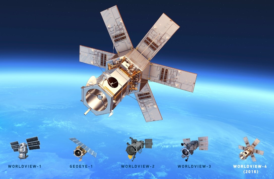
With great and extensive business partner relationship between DigitalGlobe and Asia Geomatic Instruments Sdn Bhd, we entitled to become their business partner in Malaysia from the first launch of their satellite (QuickBird) in the year 2002 until today. To date there are another 6 satellites; WorldView 1, WorldView 2, WorldView 3, WorldView 4, GeoEye 1, and Ikonos which are currently active to support the amount of high resolution satellite imagery needs throughout our country. We are the only geospatial data provider company in Malaysia capable to provide and made usage of 7 high resolution satellites (sub-meter pixel resolution) that are active and having 16 Bands Spectrum Imagery data for any kind of remote sensing application requirement.
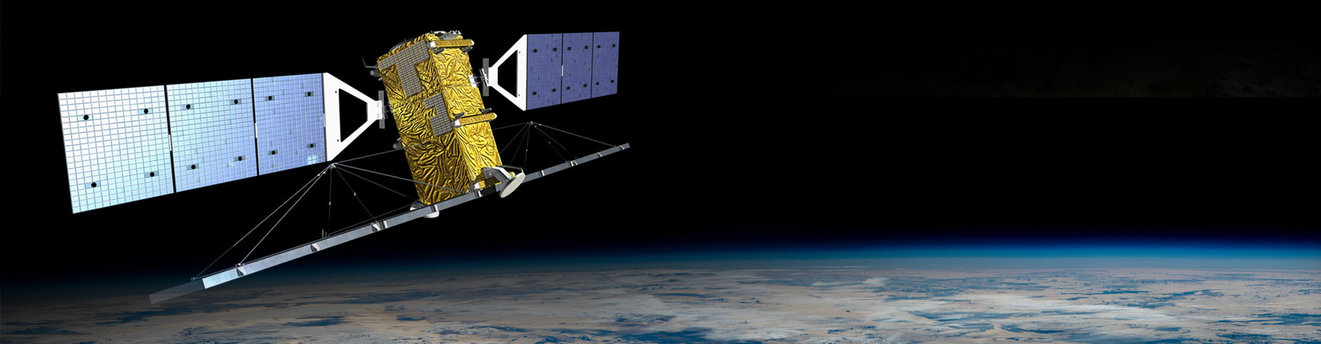
In 2010, we are appointed as Master Distributor for supplying RadarSat. 1 and RadarSat. 2 Satellite Imagery from MacDonald, Dettwiler and Associates Ltd (MDA) in Malaysia. Radar Image uses a Synthetic Aperture Radar (SAR) sensor to image the earth using microwave frequency. Unlike optical satellite that sense re-ected sunlight, SAR system transmit microwave energy towards the surface and record the
re-ections.
Thus, Radar image can image the earth, day or night in any atmospheric condition such cloud cover, dust or haze. Both satellites provide different beam modes and different image solution as subject to coverage, resolution and cost. For this Active Satellite Sensor such radar is useful for maritime surveillance, fisheries and critical mission application.From year 2013 until 2015, we have completed topographic mapping using RadarSat2 with 5 meter RMSE accuracy for whole Peninsular Malaysia, Sabah and Sarawak.
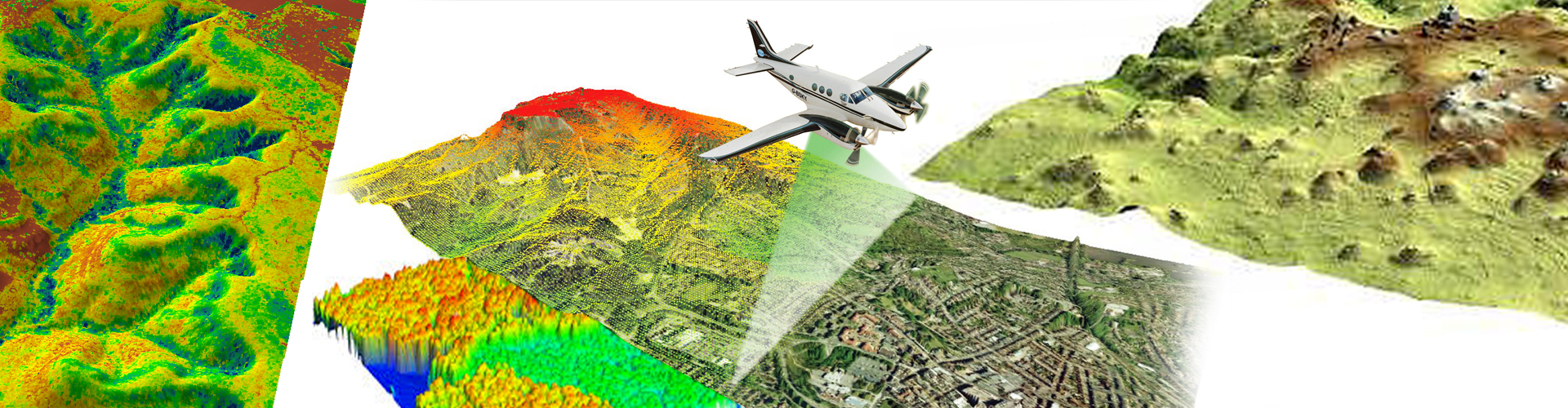
For the commitment to the Airborne Sensor Imagery sector, together with Intermap Technologies Inc, we at Asia Geomatic Instruments Sdn Bhd are able to provide IFSAR and LIDAR data respectively to the end user requirement. Airborne Sensor data has more accuracy in position comparatively to to the satellite sensor borne data. This type of data is very useful for users whom concern about precision and see it as the top priority. Both sensors have their respective business industry that comply each other.
Interferometric Synthetic Aperture Radar (IFSAR) is a radar technique that attached as Air Borne Sensor. At Asia Geomatic Instruments Sdn Bhd together with valueable relationship with Intermap Technologies Inc, we are able to provide the best available of the shelf 3D Terrain Information (Digital Elevation Model) for Malaysia in terms of Digital Surface Model and Digital Terrain Model for the usage of Energy Application, Engineering Application, Telecommunication Application and Flood Plan Management.
Light Detection and Ranging (LIDAR) is another airborne sensor technology that measures properties of scattered light to ndrange of a distant target. LIDAR data is very precise compared to IFSAR data. This technology offers one of the most accurate, expedient and cost-effective ways to capture elevation information. LIDAR data is directly processed to produce detailed bare earth models in a variety of formats including LAS, ASCII, ESRI and CAD. Typical horizontal accuracies range between 15.0 cm to 100.0 cm. Typical vertical accuracies range between 9.24 cm and 18.5 cm for fixed wing aircraft. Most Lidar are widely used for high accuracy demand sector such Digital Elevation Model and Building Footprint marking and Height Measurement or any application that precise demanding.
exactEarth
Founded in 2009, exactEarth was established for the purpose of making Satellite AIS data services available to the global maritime market. Based in Cambridge, Ontario, Canada, exactEarth leverages advanced microsatellite technology to deliver vessel monitoring solutions characterised by high performance, reliability, security, and simplicity.
exactEarth is a leading organisation in the field of global AIS vessel tracking, collecting the most comprehensive ship monitoring data and delivering the highest quality information to customers around the world.
exactEarth ShipViewTM is an easy-to-use, modern web-based viewing tool that allows users to see all the ship positions produced by their exactAIS® data service and then plots them on a familiar set of map layers to enhance the viewing experience.
Users can access ShipView from anywhere and anytime to gain greater visibility into all the maritime traffic currentlytraversing our oceans. With a rich set of filtering and analysis tools at your fingertips, ShipView provides you with the traffic view and information you need to make critical maritime operational decisions easier and faster than ever before.
THE SHIPVIEW ADVANTAGE
Increased Operational Efficiencies:
exactEarth hosts the ShipView web application and all data to serve you on demand, giving you the ability to access the application anywhere, anytime, and on most devices. With instant access to dynamic, comprehensive and accurate ship information over the internet, analysis on ship behavioural patterns is easier than ever, saving users valuable time, money and effort.
Improved Decision Making:
Simplifying processes for decision making is key in the ShipView design. Out of the box tools are available for searching and filtering maritime traffic to assist in streamlining decision making. ShipView quickly and easily provides the information needed to make timely, critical decisions in maritime operations; with instant alerting available, users gain even greater awareness into vessel behaviour, allowing for informed decisions and immediate action.
Enhanced Maritime Monitoring
ShipView is equipped with exactEarth’s reliable and globally trusted exactAIS data service to provide the most comprehensive maritime domain awareness available.
Data provided to users includes Ship Location, Ship Course, MMSI, Ship Speed and a 90-day track lookback.
Unmanned Aerial Vehicle (UAV)
Asia Geomatic Instruments Sdn Bhd has added the capability to collect/Sell high-resolution imagery from a small, Unmanned Aerial Vehicle (UAV), SmartPlanes, latest technology from Sweden. This system is safe, efficient and cost-competitive in comparison to traditional fixed- wing / helicopter-based data collection platforms and terrestrial survey operations. The collected imagery can be efficiently processed to generate digital surface models, topography and imagery data products to integrate into both CAD and GIS systems.
SmartPlanes professional commercial UAS / UAV / Drones nowadays are performing missions of surveying, mapping, city-planning, mining, forestry, agriculture, volume calculations, science, wildlife protection and much more. A complete aerial geomatics, geospatial technology, equipment platform for georeferenced orthophotography and 3D modelling. Prepared for use with multiple sensors, ranging from e.g. cameras to thermal imaging, multi and hyper spectral, lidar and magnetometer. The production of Digital Terrain Models, DTM and Digital Surface Models, DSM, for Geographic Information Systems, GIS, is done through partner software like e.g. Pix4d and Agisoft.